 The start of August is usually way too early for me to seriously start looking into what kind of winter we might have. But there are a couple of strong signatures in the Pacific and Atlantic oceans that have grabbed my attention.
Why are ocean temperature patterns so important? Water has high specific heat when compared to air. In other words, the oceans heat up and cool down much slower than the atmosphere does. Sea surface temperature patterns over the oceans often take hold for months. The vast amount of heat energy stored in the oceans can drive prevailing weather patterns for extended periods of time.
Pacific Decadal Oscillation
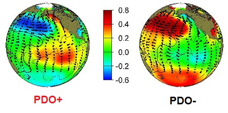
Over the North Pacific, warm water pooled in the Gulf of Alaska and cold water pooled off-shore from Russia marks the positive phase of the Pacific Decadal Oscillation (PDO+) as modeled on the following panel:
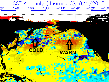
The pool of warm water in the Gulf of Alaska strongly tele-connects with prevailing warm and dry weather over the western United States. This forces the jet stream to buckle into a trough over the eastern United States, favoring cold and stormy weather here. Look at the sea surface temperature anomaly chart for early August:
That’s a decent match to the PDO+ model. Assuming this pattern holds into October and November, I think winter will jump to a much quicker start than it has in recent years.
North Atlantic Tripole
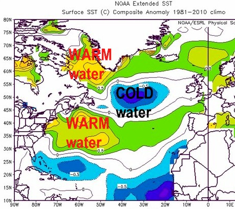
As most followers of winter weather probably know, the negative phase of the North Atlantic Oscillation (NAO-) is usually expressed as a mountain of relatively warm air over Greenland that forces cold air to deeply plunge into the eastern United States in winter. This tripole pattern of warm-cold-warm water in the North Atlantic is usually a strong precursor for prevailing NAO- during the cold season:
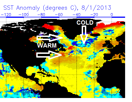
The sea surface temperature anomaly chart for early August shows a classic warm-cold-warm tripole!
Assuming this pattern holds into winter, there should be ample opportunity for the fabled “Greenland blocking” that is often conducive for coastal storm development and arctic outbreaks.
(Early) Winter Outlook
Like I said at the beginning: Early August is very early to stick one’s neck out on a winter seasonal outlook. However, I believe there is potential to have a winter on par with the five snowiest winters in the past 15 years at Indian Lake:
2002-03: 152.8″
2000-01: 140.2″
2007-08: 132.9″
2008-09: 124.1″
2010-11: 120.5″
Out of those top-5 winters, only 2002-03 had both PDO+ and North Atlantic Tripole on October 1st. That was an awesome winter! Winter came on like gangbusters in November and December and carried on well into spring with record snow and cold into April. It would be foolish to predict an exact replica for 2013-14, but there is reason to get excited! If the Vegas odds makers would place the over/under for Indian Lake snowfall at 115″ this winter, which is near the average, I’d take the “over” in a New York minute.
Of course, we’ll have to monitor the spread of Eurasian snow cover in October to see whether the weather matches the theory. But hope in August is a GOOD THING. 🙂
What outlooks have you seen for 2013-14? It would be fun to compare notes.


