WOW! There has been lots of internet and media consternation over the upcoming storm. Lots of flip-flopping, ping-pong forecasting out there with each model run every 6 hours.
I try to avoid that, because in the end, it’s a meaningless exercise. Back on the 29th, I showed how the upcoming North American weather pattern supported the idea of a meaningful snow event.
That idea hasn’t changed through all of the models flips and flops. As we get closer to the event, the details are starting to come into focus.
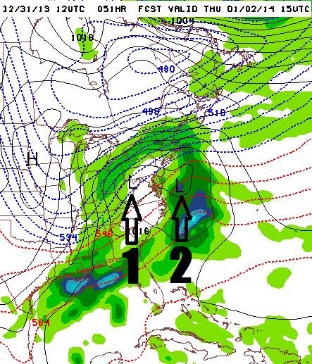
I think the biggest presupposition that will turn out to be incorrect is the notion this storm will be a true coastal nor’easter. The NAM, with decent cross-model support, is showing TWO low centers. Number 1 is the northern stream low with the Arctic jet. Number 2 is the southern stream low with the subtropical jet, in the process of getting booted out to sea Thursday morning:

That is a critically important detail because I think the lion’s share of the precipitation over the northeastern United States for Thursday storm will be generated by the Arctic jet. Look above and see where the precipitation would be falling Thursday morning: a snow event in progress over Upstate New York with next to nothing happening over eastern Pennsylvania, New York City or New Jersey.
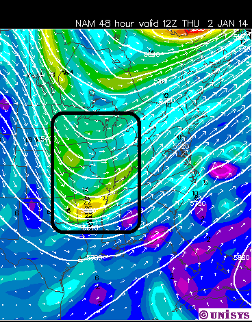
The 500mb map for Thursday morning shows WHY this is happening:

All of the energy is hanging back in the central United States, fueling the northern stream low while a broad southwesterly flow pushes the subtropical jet out to sea. The reason I think we’re still in for a significant snow event is because the northern stream storm should have enough dynamic energy to get the job done, generating sufficient lift over the sagging Arctic front. However, don’t expect anything close to Valentine’s Day 2007 Blizzard or Superstorm ’93 because it’s neither kind of set-up. Those storms do not grow on trees.
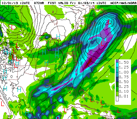
This panel shows the 12Z NAM’s projected liquid precipitation totals for Thursday’s storm:

The forecast half-inch of liquid precip for the ilsnow.com storm center doesn’t sound tremendously exciting. But generating that amount of precipitation in an Arctic environment could produce a decent pile of snow. If this map is true, places in east-central New York that haven’t seen much snow the past two winters should do very well from this! It’s still a dangerous game to issue specific snowfall forecasts right now because the area of significant snowfall will be relatively small. Small changes in details could seriously rock the apple cart to a snowfall forecast made today.
Having said all of that, I think ilsnow land should be on decent footing for a riding weekend. Good thing too because my XP is getting grumpy just sitting there in her stall.
Keep check on my latest forecasts at:
www.ilsnow.com/weather
Darrin @ ilsnow.com

